01
Enter the address
That is all we need to research the parcel, owner record, municipality and available map data.
Start with only the property address. We review available public parcel and building records with aerial imagery to create a clean GIS-based existing-conditions exhibit.
Address-first ordering
Enter the property address. We research the parcel, municipality and visible site conditions for you.
A practical planning workflow
Every plan follows the same research, alignment and visual-QA process before it is released.
That is all we need to research the parcel, owner record, municipality and available map data.
We compare official parcel and building records with multiple aerial views and select the clearest useful imagery.
Parcel and building geometry must align on the same orthophoto. If they do not, drafting stops for more research.
We trace visible improvements only after alignment passes, render-check the sheet and deliver the 11×17 PDF.
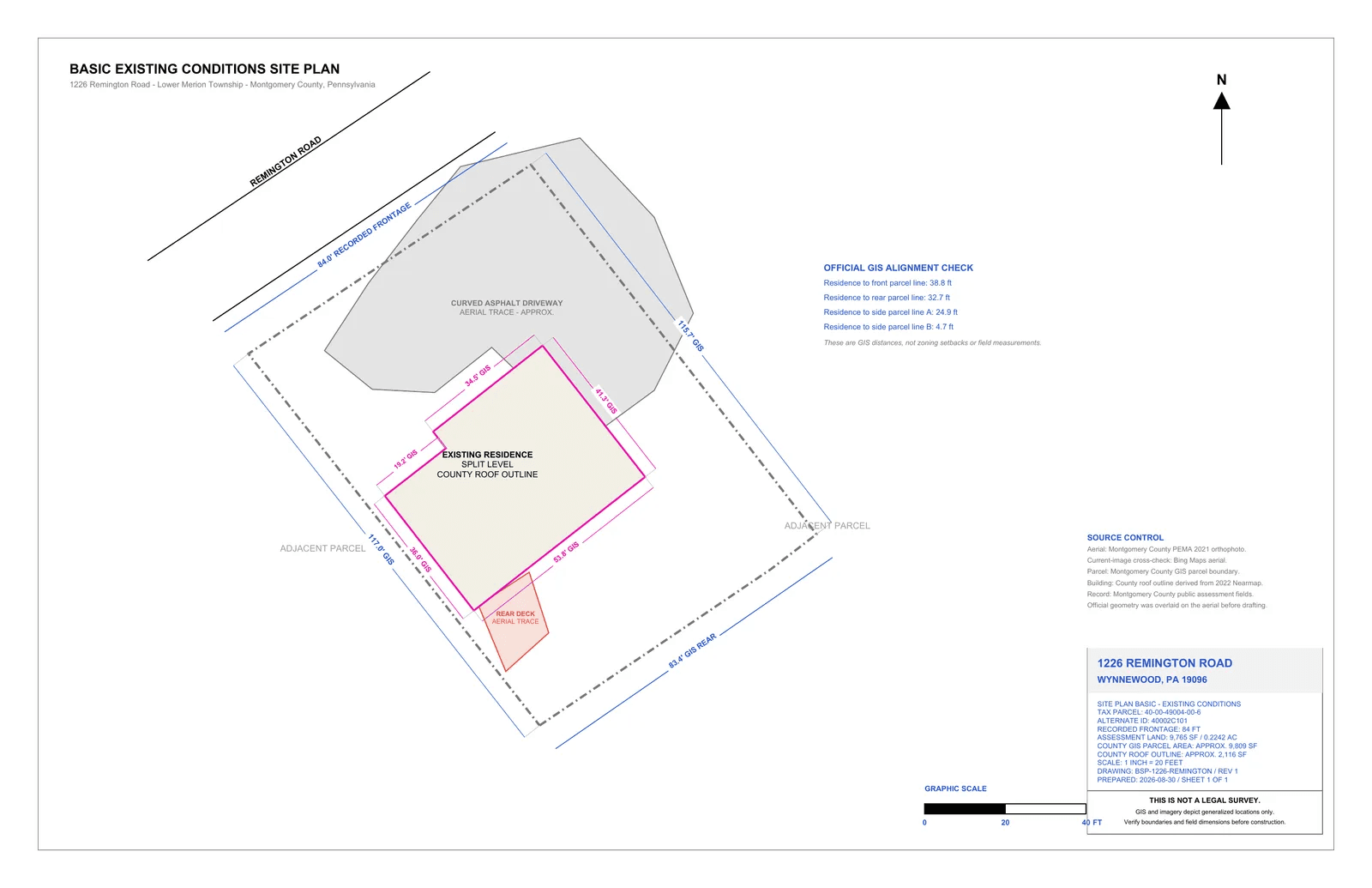
Approved sample deliverable
A clean preliminary existing-conditions exhibit showing the parcel, residence, driveway and visible site improvements with source notes. It is not a legal survey or a guaranteed permit plan.
Sample shown for format and detail. Every property is researched individually. This product is not a legal boundary survey.
Simple flat price
Now accepting residential addresses in Montgomery and Bucks Counties, PA, and Burlington County, NJ. Standard turnaround is 2–3 business days after payment and source verification. Pay and submit the request together; data conflicts are routed to owner review.
Property research & permit support
Choose only the information and clerical support your project needs. Each result identifies its public source and research date.
We identify the municipality and zoning district, then research published front, side and rear setback requirements from official municipal sources.
We research available assessor or recorder sources and provide the owner name shown, together with the source and research date.
We research the municipality’s published impervious limit and estimate coverage using the lot area and visible structures and paved surfaces.
Clerical filing assistance for townships that accept counter submission. Account-based online portal applications are outside this service.
Research services are informational and are not legal opinions, surveys, official zoning determinations, permit approvals or professional design services. Requirements and records must be confirmed with the reviewing authority.
Site Plan Basic, zoning and setback research, and an impervious coverage estimate. Save $10 compared with ordering each service separately.
A fast existing-conditions exhibit for transaction review. It does not determine permit status, code compliance, or legal boundaries.
For contractors ordering 3 or more paid standard-turnaround plans per calendar month, with one billing contact and email-only intake.
Request contractor intakeClear service boundaries
No boundary surveys, engineering, architecture, legal opinions, appraisals, utility locating, or signed, sealed or stamped plans.
GIS boundaries and aerial traces are approximate and must not be used to establish legal boundaries or field construction dimensions.
Start your order
Measurements, surveys and photos are optional. Add them only if they help show proposed work or features hidden from aerial view.
We find the parcel number, owner record and municipality.
Your documents are used only to evaluate and prepare your requested services.
Common questions
No. Site Plan Basic is a non-certified existing-conditions drawing built from public GIS records and aerial imagery.
Only the property address is required to begin. Surveys, photos and sketches are optional.
Standard turnaround is 2–3 business days after payment and source verification. If records conflict, timing pauses while we contact you. Rush orders target less than 12 business hours Monday–Friday after source coverage is confirmed.
Requirements vary by municipality and project. Confirm the required plan type with the reviewing authority before ordering.
We do not access or submit account-based online portals. Counter-submission filing assistance is available only where the township accepts that method.
We stop the automated workflow and route the paid order to owner review. If we cannot complete the plan after manual review, the affected service is refunded. We never invent missing dimensions.
One submission-ready sheet
This non-certified site plan is prepared from public GIS records, available aerial imagery and optional customer information. It is not a boundary survey and cannot establish legal property lines. Verify boundaries and field dimensions before construction. Acceptance requirements vary by jurisdiction.